|
|
|||||||||||||||||
| Point ID: 6467 | Downloads | Plots | Site Data | Code: 8155 |
|
|
|||||||||||||||||
| Download | |
|---|---|
| Site Descriptor Information | Site Time Series Data |
| Link to all available data | |
| View: | Time Series | All |
| Units: | m3/s |
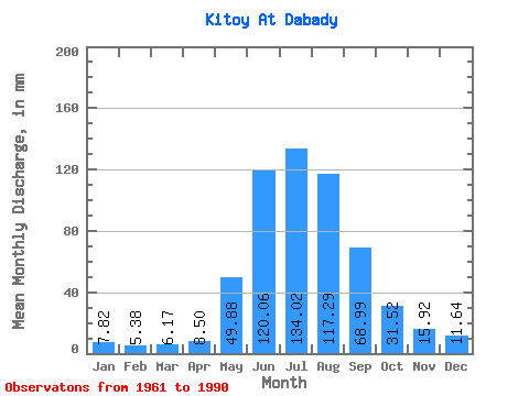
| Statistic | Jan | Feb | Mar | Apr | May | Jun | Jul | Aug | Sep | Oct | Nov | Dec | Annual |
|---|---|---|---|---|---|---|---|---|---|---|---|---|---|
| Mean | 7.82 | 5.42 | 6.17 | 8.50 | 49.88 | 120.06 | 134.00 | 117.28 | 68.98 | 31.51 | 15.92 | 11.64 | 562.87 |
| Standard Deviation | 1.86 | 0.93 | 0.89 | 2.79 | 16.23 | 34.75 | 28.53 | 31.88 | 17.75 | 6.08 | 3.11 | 2.38 | 79.51 |
| Min | 4.58 | 3.41 | 4.26 | 4.58 | 18.45 | 68.77 | 79.93 | 68.04 | 46.68 | 20.63 | 10.65 | 7.86 | 429.52 |
| Max | 11.41 | 7.03 | 8.81 | 16.07 | 81.30 | 204.32 | 202.22 | 211.10 | 115.71 | 41.95 | 23.21 | 15.58 | 699.10 |
| Coefficient of Variation | 0.24 | 0.17 | 0.14 | 0.33 | 0.33 | 0.29 | 0.21 | 0.27 | 0.26 | 0.19 | 0.20 | 0.20 | 0.14 |
 Return to R-Arctic Net Home Page