|
|
|||||||||||||||||
| Point ID: 6461 | Downloads | Plots | Site Data | Code: 8097 |
|
|
|||||||||||||||||
| Download | |
|---|---|
| Site Descriptor Information | Site Time Series Data |
| Link to all available data | |
| View: | Time Series | All |
| Units: | m3/s |
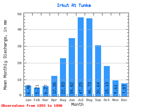
| Statistic | Jan | Feb | Mar | Apr | May | Jun | Jul | Aug | Sep | Oct | Nov | Dec | Annual |
|---|---|---|---|---|---|---|---|---|---|---|---|---|---|
| Mean | 6.46 | 5.25 | 6.27 | 12.36 | 22.83 | 34.82 | 47.24 | 46.72 | 30.64 | 18.13 | 9.61 | 7.87 | 247.53 |
| Standard Deviation | 1.19 | 0.83 | 1.11 | 2.76 | 6.63 | 9.51 | 11.76 | 15.06 | 8.11 | 3.02 | 2.09 | 1.38 | 36.70 |
| Min | 4.33 | 3.62 | 3.41 | 5.29 | 10.98 | 17.82 | 23.96 | 23.19 | 18.69 | 11.39 | 6.01 | 4.90 | 178.09 |
| Max | 8.86 | 7.22 | 8.94 | 19.48 | 37.52 | 58.87 | 73.89 | 88.59 | 46.62 | 24.25 | 15.17 | 10.82 | 317.32 |
| Coefficient of Variation | 0.18 | 0.16 | 0.18 | 0.22 | 0.29 | 0.27 | 0.25 | 0.32 | 0.27 | 0.17 | 0.22 | 0.17 | 0.15 |
 Return to R-Arctic Net Home Page