|
|
|||||||||||||||||
| Point ID: 6460 | Downloads | Plots | Site Data | Code: 8095 |
|
|
|||||||||||||||||
| Download | |
|---|---|
| Site Descriptor Information | Site Time Series Data |
| Link to all available data | |
| View: | Time Series | All |
| Units: | m3/s |
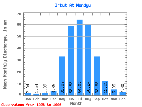
| Statistic | Jan | Feb | Mar | Apr | May | Jun | Jul | Aug | Sep | Oct | Nov | Dec | Annual |
|---|---|---|---|---|---|---|---|---|---|---|---|---|---|
| Mean | 2.04 | 1.65 | 1.99 | 3.86 | 32.86 | 58.53 | 64.06 | 60.23 | 32.88 | 12.24 | 5.05 | 2.80 | 276.64 |
| Standard Deviation | 0.65 | 0.57 | 0.56 | 2.70 | 14.99 | 16.52 | 20.45 | 22.84 | 8.63 | 3.93 | 1.57 | 0.64 | 48.16 |
| Min | 0.96 | 0.59 | 0.69 | 0.84 | 10.91 | 29.38 | 33.25 | 30.13 | 16.44 | 6.03 | 1.90 | 1.70 | 182.74 |
| Max | 4.29 | 2.66 | 2.97 | 17.24 | 86.14 | 91.58 | 133.01 | 134.35 | 46.87 | 25.89 | 8.34 | 4.11 | 424.24 |
| Coefficient of Variation | 0.32 | 0.35 | 0.28 | 0.70 | 0.46 | 0.28 | 0.32 | 0.38 | 0.26 | 0.32 | 0.31 | 0.23 | 0.17 |
 Return to R-Arctic Net Home Page