|
|
|||||||||||||||||
| Point ID: 6426 | Downloads | Plots | Site Data | Code: 7093 |
|
|
|||||||||||||||||
| Download | |
|---|---|
| Site Descriptor Information | Site Time Series Data |
| Link to all available data | |
| View: | Time Series | All |
| Units: | m3/s |
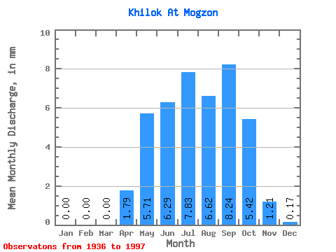
| Statistic | Jan | Feb | Mar | Apr | May | Jun | Jul | Aug | Sep | Oct | Nov | Dec | Annual |
|---|---|---|---|---|---|---|---|---|---|---|---|---|---|
| Mean | 0.00 | 0.00 | 0.00 | 1.79 | 5.71 | 6.29 | 7.82 | 6.62 | 8.24 | 5.42 | 1.21 | 0.17 | 42.65 |
| Standard Deviation | 0.00 | 0.00 | 0.00 | 2.51 | 5.23 | 8.51 | 7.46 | 6.55 | 7.99 | 5.03 | 1.26 | 0.24 | 35.18 |
| Min | 0.00 | 0.00 | 0.00 | 0.00 | 0.28 | 0.14 | 0.12 | 0.05 | 0.07 | 0.04 | 0.00 | 0.00 | 1.55 |
| Max | 0.00 | 0.00 | 0.00 | 11.36 | 21.49 | 36.00 | 25.29 | 24.47 | 29.36 | 17.19 | 3.54 | 0.83 | 122.61 |
| Coefficient of Variation | 1.40 | 0.92 | 1.35 | 0.95 | 0.99 | 0.97 | 0.93 | 1.04 | 1.44 | 0.82 |
 Return to R-Arctic Net Home Page