|
|
|||||||||||||||||
| Point ID: 6425 | Downloads | Plots | Site Data | Code: 7092 |
|
|
|||||||||||||||||
| Download | |
|---|---|
| Site Descriptor Information | Site Time Series Data |
| Link to all available data | |
| View: | Time Series | All |
| Units: | m3/s |
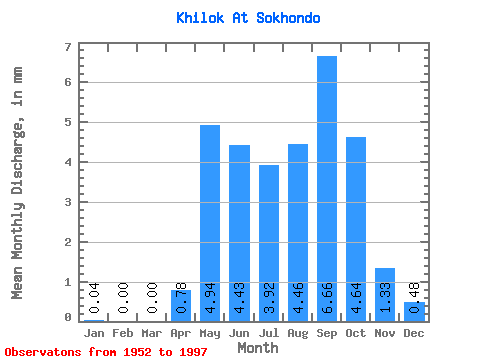
| Statistic | Jan | Feb | Mar | Apr | May | Jun | Jul | Aug | Sep | Oct | Nov | Dec | Annual |
|---|---|---|---|---|---|---|---|---|---|---|---|---|---|
| Mean | 0.04 | 0.00 | 0.00 | 0.78 | 4.94 | 4.43 | 3.92 | 4.46 | 6.66 | 4.63 | 1.33 | 0.48 | 42.41 |
| Standard Deviation | 0.09 | 0.00 | 0.01 | 1.37 | 6.09 | 8.42 | 7.36 | 6.73 | 10.90 | 5.87 | 1.64 | 0.71 | 50.06 |
| Min | 0.00 | 0.00 | 0.00 | 0.00 | 0.00 | 0.01 | 0.01 | 0.00 | 0.00 | 0.04 | 0.00 | 0.00 | 2.44 |
| Max | 0.34 | 0.00 | 0.03 | 6.49 | 30.73 | 42.56 | 39.18 | 25.23 | 49.66 | 24.38 | 6.74 | 2.92 | 183.80 |
| Coefficient of Variation | 2.41 | 4.36 | 1.76 | 1.23 | 1.90 | 1.88 | 1.51 | 1.64 | 1.27 | 1.23 | 1.47 | 1.18 |
 Return to R-Arctic Net Home Page