|
|
|||||||||||||||||
| Point ID: 642 | Downloads | Plots | Site Data | Code: 07BA002 |
|
|
|||||||||||||||||
| Download | |
|---|---|
| Site Descriptor Information | Site Time Series Data |
| Link to all available data | |
| View: | Time Series | All |
| Units: | m3/s |
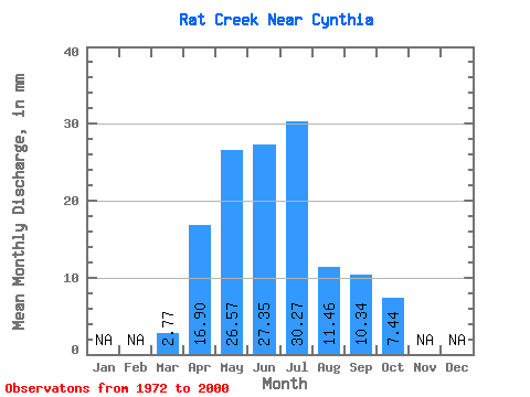
| Statistic | Jan | Feb | Mar | Apr | May | Jun | Jul | Aug | Sep | Oct | Nov | Dec | Annual |
|---|---|---|---|---|---|---|---|---|---|---|---|---|---|
| Mean | 2.66 | 16.28 | 25.60 | 26.36 | 29.17 | 11.05 | 9.96 | 7.17 | |||||
| Standard Deviation | 2.42 | 11.99 | 19.69 | 24.03 | 26.12 | 9.44 | 9.48 | 4.98 | |||||
| Min | 0.43 | 2.89 | 1.68 | 6.76 | 1.84 | 0.93 | 1.84 | 1.84 | |||||
| Max | 13.92 | 50.04 | 78.66 | 95.81 | 135.23 | 40.04 | 33.28 | 20.77 | |||||
| Coefficient of Variation | 0.91 | 0.74 | 0.77 | 0.91 | 0.90 | 0.85 | 0.95 | 0.69 |
 Return to R-Arctic Net Home Page