|
|
|||||||||||||||||
| Point ID: 6415 | Downloads | Plots | Site Data | Other Close Sites | Code: 7060 |
|
|
|||||||||||||||||
| Download | |
|---|---|
| Site Descriptor Information | Site Time Series Data |
| Link to all available data | |
| View: | Time Series | All |
| Units: | m3/s |
| Statistic | Jan | Feb | Mar | Apr | May | Jun | Jul | Aug | Sep | Oct | Nov | Dec | Annual |
|---|---|---|---|---|---|---|---|---|---|---|---|---|---|
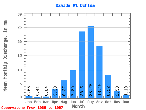
| Mean | 0.65 | 0.42 | 0.64 | 3.39 | 6.27 | 9.79 | 23.51 | 25.27 | 18.46 | 8.22 | 2.50 | 1.13 | 99.61 |
| Standard Deviation | 0.40 | 0.27 | 0.38 | 1.15 | 2.65 | 7.67 | 13.78 | 16.24 | 13.66 | 4.04 | 1.19 | 0.59 | 41.56 |
| Min | 0.16 | 0.07 | 0.10 | 1.19 | 2.55 | 1.78 | 4.32 | 5.77 | 4.30 | 3.69 | 1.08 | 0.21 | 43.44 |
| Max | 2.15 | 1.47 | 1.87 | 6.20 | 13.79 | 47.95 | 71.26 | 96.43 | 62.96 | 21.26 | 6.64 | 2.94 | 225.43 |
| Coefficient of Variation | 0.62 | 0.66 | 0.58 | 0.34 | 0.42 | 0.78 | 0.59 | 0.64 | 0.74 | 0.49 | 0.47 | 0.52 | 0.42 |
| Other Close Sites | ||||||
|---|---|---|---|---|---|---|
| PointID | Latitude | Longitude | Drainage Area | Source | Name | |
| 6410 | "Selenga At Naushky" | 50.40 | 1198435 | SHI | 402.00 | |
 Return to R-Arctic Net Home Page