|
|
|||||||||||||||||
| Point ID: 6406 | Downloads | Plots | Site Data | Code: 7029 |
|
|
|||||||||||||||||
| Download | |
|---|---|
| Site Descriptor Information | Site Time Series Data |
| Link to all available data | |
| View: | Time Series | All |
| Units: | m3/s |
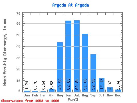
| Statistic | Jan | Feb | Mar | Apr | May | Jun | Jul | Aug | Sep | Oct | Nov | Dec | Annual |
|---|---|---|---|---|---|---|---|---|---|---|---|---|---|
| Mean | 1.24 | 0.76 | 0.64 | 2.52 | 43.49 | 62.69 | 62.83 | 51.05 | 32.95 | 12.13 | 4.01 | 2.04 | 274.81 |
| Standard Deviation | 1.04 | 0.64 | 0.48 | 2.90 | 17.88 | 30.55 | 39.31 | 23.99 | 16.23 | 5.59 | 2.69 | 1.37 | 80.82 |
| Min | 0.16 | 0.04 | 0.09 | 0.35 | 19.70 | 23.80 | 15.17 | 17.89 | 9.00 | 4.48 | 1.04 | 0.49 | 140.85 |
| Max | 5.04 | 2.84 | 1.58 | 17.32 | 94.95 | 134.31 | 187.70 | 109.07 | 72.11 | 25.32 | 12.70 | 7.62 | 436.44 |
| Coefficient of Variation | 0.83 | 0.83 | 0.75 | 1.15 | 0.41 | 0.49 | 0.63 | 0.47 | 0.49 | 0.46 | 0.67 | 0.67 | 0.29 |
 Return to R-Arctic Net Home Page