|
|
|||||||||||||||||
| Point ID: 640 | Downloads | Plots | Site Data | Code: 07AH003 |
|
|
|||||||||||||||||
| Download | |
|---|---|
| Site Descriptor Information | Site Time Series Data |
| Link to all available data | |
| View: | Time Series | All |
| Units: | m3/s |
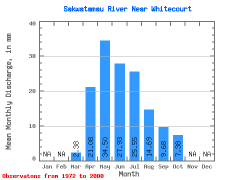
| Statistic | Jan | Feb | Mar | Apr | May | Jun | Jul | Aug | Sep | Oct | Nov | Dec | Annual |
|---|---|---|---|---|---|---|---|---|---|---|---|---|---|
| Mean | 2.38 | 21.08 | 34.50 | 27.93 | 25.55 | 14.69 | 9.68 | 7.38 | |||||
| Standard Deviation | 1.54 | 12.18 | 20.05 | 18.38 | 18.48 | 14.56 | 6.81 | 4.54 | |||||
| Min | 1.00 | 4.71 | 9.28 | 6.98 | 5.54 | 3.36 | 1.86 | 2.58 | |||||
| Max | 9.37 | 48.88 | 79.40 | 90.27 | 90.44 | 70.71 | 27.74 | 21.78 | |||||
| Coefficient of Variation | 0.65 | 0.58 | 0.58 | 0.66 | 0.72 | 0.99 | 0.70 | 0.61 |
 Return to R-Arctic Net Home Page