|
|
|||||||||||||||||
| Point ID: 6351 | Downloads | Plots | Site Data | Code: 3860 |
|
|
|||||||||||||||||
| Download | |
|---|---|
| Site Descriptor Information | Site Time Series Data |
| Link to all available data | |
| View: | Time Series | All |
| Units: | m3/s |
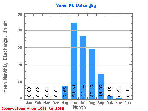
| Statistic | Jan | Feb | Mar | Apr | May | Jun | Jul | Aug | Sep | Oct | Nov | Dec | Annual |
|---|---|---|---|---|---|---|---|---|---|---|---|---|---|
| Mean | 0.03 | 0.01 | 0.01 | 0.01 | 7.65 | 44.51 | 36.63 | 29.17 | 14.87 | 2.15 | 0.44 | 0.10 | 135.10 |
| Standard Deviation | 0.03 | 0.02 | 0.03 | 0.02 | 6.94 | 14.16 | 12.36 | 14.02 | 6.87 | 1.20 | 0.22 | 0.09 | 28.50 |
| Min | 0.00 | 0.00 | 0.00 | 0.00 | 0.00 | 16.56 | 11.90 | 0.00 | 0.00 | 0.00 | 0.00 | 0.00 | 79.29 |
| Max | 0.12 | 0.12 | 0.14 | 0.15 | 38.81 | 82.92 | 69.43 | 66.58 | 31.80 | 7.26 | 1.14 | 0.57 | 211.13 |
| Coefficient of Variation | 0.89 | 1.55 | 1.91 | 2.05 | 0.91 | 0.32 | 0.34 | 0.48 | 0.46 | 0.56 | 0.51 | 0.82 | 0.21 |
 Return to R-Arctic Net Home Page