|
|
|||||||||||||||||
| Point ID: 6338 | Downloads | Plots | Site Data | Code: 3801 |
|
|
|||||||||||||||||
| Download | |
|---|---|
| Site Descriptor Information | Site Time Series Data |
| Link to all available data | |
| View: | Time Series | All |
| Units: | m3/s |
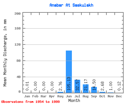
| Statistic | Jan | Feb | Mar | Apr | May | Jun | Jul | Aug | Sep | Oct | Nov | Dec | Annual |
|---|---|---|---|---|---|---|---|---|---|---|---|---|---|
| Mean | 0.01 | 0.00 | 0.00 | 0.00 | 2.76 | 105.13 | 32.56 | 21.17 | 14.50 | 2.68 | 1.00 | 0.12 | 181.36 |
| Standard Deviation | 0.05 | 0.00 | 0.00 | 0.00 | 6.58 | 23.12 | 23.80 | 17.53 | 11.35 | 1.94 | 3.18 | 0.39 | 46.21 |
| Min | 0.00 | 0.00 | 0.00 | 0.00 | 0.00 | 58.55 | 2.97 | 1.71 | 0.78 | 0.10 | 0.00 | 0.00 | 69.40 |
| Max | 0.28 | 0.00 | 0.00 | 0.00 | 28.82 | 164.47 | 126.08 | 76.47 | 48.68 | 7.99 | 21.35 | 2.00 | 276.03 |
| Coefficient of Variation | 4.80 | 2.38 | 0.22 | 0.73 | 0.83 | 0.78 | 0.72 | 3.19 | 3.15 | 0.26 |
 Return to R-Arctic Net Home Page