|
|
|||||||||||||||||
| Point ID: 6333 | Downloads | Plots | Site Data | Code: 3607 |
|
|
|||||||||||||||||
| Download | |
|---|---|
| Site Descriptor Information | Site Time Series Data |
| Link to all available data | |
| View: | Time Series | All |
| Units: | m3/s |
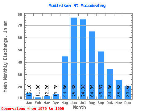
| Statistic | Jan | Feb | Mar | Apr | May | Jun | Jul | Aug | Sep | Oct | Nov | Dec | Annual |
|---|---|---|---|---|---|---|---|---|---|---|---|---|---|
| Mean | 15.18 | 11.46 | 12.26 | 13.78 | 44.86 | 76.38 | 74.81 | 64.98 | 48.87 | 34.35 | 25.63 | 20.50 | 441.55 |
| Standard Deviation | 4.75 | 3.22 | 3.78 | 2.91 | 20.09 | 31.22 | 52.05 | 35.19 | 22.72 | 6.84 | 5.99 | 8.36 | 115.33 |
| Min | 8.24 | 6.14 | 4.36 | 8.77 | 23.38 | 35.82 | 16.25 | 18.72 | 21.99 | 24.91 | 19.95 | 8.52 | 266.90 |
| Max | 23.26 | 16.45 | 18.32 | 18.55 | 86.66 | 138.92 | 170.31 | 133.90 | 101.93 | 42.73 | 37.28 | 39.12 | 671.65 |
| Coefficient of Variation | 0.31 | 0.28 | 0.31 | 0.21 | 0.45 | 0.41 | 0.70 | 0.54 | 0.47 | 0.20 | 0.23 | 0.41 | 0.26 |
 Return to R-Arctic Net Home Page