|
|
|||||||||||||||||
| Point ID: 6330 | Downloads | Plots | Site Data | Code: 3581 |
|
|
|||||||||||||||||
| Download | |
|---|---|
| Site Descriptor Information | Site Time Series Data |
| Link to all available data | |
| View: | Time Series | All |
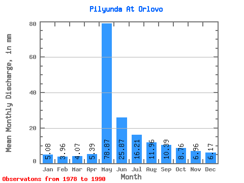
| Units: | m3/s |
| Statistic | Jan | Feb | Mar | Apr | May | Jun | Jul | Aug | Sep | Oct | Nov | Dec | Annual |
|---|---|---|---|---|---|---|---|---|---|---|---|---|---|
| Mean | 5.08 | 3.99 | 4.07 | 5.39 | 78.85 | 25.87 | 16.20 | 11.96 | 10.39 | 8.76 | 6.96 | 6.17 | 182.37 |
| Standard Deviation | 1.47 | 1.24 | 1.24 | 4.16 | 18.12 | 11.10 | 7.01 | 3.14 | 3.69 | 2.71 | 1.95 | 1.75 | 37.42 |
| Min | 3.33 | 2.50 | 2.15 | 2.37 | 47.78 | 12.41 | 8.10 | 7.29 | 6.21 | 5.23 | 4.23 | 3.70 | 130.83 |
| Max | 8.61 | 6.74 | 6.54 | 18.85 | 108.19 | 50.22 | 30.43 | 19.32 | 20.77 | 15.67 | 12.21 | 10.88 | 265.56 |
| Coefficient of Variation | 0.29 | 0.31 | 0.30 | 0.77 | 0.23 | 0.43 | 0.43 | 0.26 | 0.35 | 0.31 | 0.28 | 0.28 | 0.20 |
 Return to R-Arctic Net Home Page