|
|
|||||||||||||||||
| Point ID: 6329 | Downloads | Plots | Site Data | Code: 3579 |
|
|
|||||||||||||||||
| Download | |
|---|---|
| Site Descriptor Information | Site Time Series Data |
| Link to all available data | |
| View: | Time Series | All |
| Units: | m3/s |
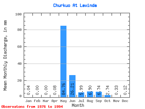
| Statistic | Jan | Feb | Mar | Apr | May | Jun | Jul | Aug | Sep | Oct | Nov | Dec | Annual |
|---|---|---|---|---|---|---|---|---|---|---|---|---|---|
| Mean | 0.04 | 0.00 | 0.00 | 0.08 | 84.75 | 26.21 | 5.99 | 6.90 | 6.74 | 2.74 | 0.33 | 0.12 | 132.56 |
| Standard Deviation | 0.05 | 0.00 | 0.00 | 0.23 | 27.26 | 17.13 | 9.40 | 9.68 | 7.77 | 2.85 | 0.33 | 0.13 | 44.65 |
| Min | 0.00 | 0.00 | 0.00 | 0.00 | 43.45 | 2.48 | 1.06 | 0.24 | 0.16 | 0.17 | 0.09 | 0.00 | 53.84 |
| Max | 0.21 | 0.01 | 0.00 | 0.93 | 140.06 | 52.22 | 38.58 | 34.50 | 24.79 | 8.88 | 1.16 | 0.45 | 210.66 |
| Coefficient of Variation | 1.49 | 2.11 | 4.12 | 3.05 | 0.32 | 0.65 | 1.57 | 1.40 | 1.15 | 1.04 | 1.00 | 1.12 | 0.34 |
 Return to R-Arctic Net Home Page