|
|
|||||||||||||||||
| Point ID: 6324 | Downloads | Plots | Site Data | Code: 3569 |
|
|
|||||||||||||||||
| Download | |
|---|---|
| Site Descriptor Information | Site Time Series Data |
| Link to all available data | |
| View: | Time Series | All |
| Units: | m3/s |
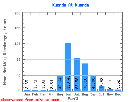
| Statistic | Jan | Feb | Mar | Apr | May | Jun | Jul | Aug | Sep | Oct | Nov | Dec | Annual |
|---|---|---|---|---|---|---|---|---|---|---|---|---|---|
| Mean | 2.65 | 1.75 | 1.98 | 3.34 | 40.63 | 120.48 | 83.57 | 70.15 | 40.00 | 12.57 | 6.10 | 3.62 | 411.43 |
| Standard Deviation | 1.01 | 0.85 | 1.06 | 1.45 | 26.76 | 48.22 | 57.87 | 51.04 | 23.59 | 4.43 | 1.79 | 0.83 | 126.78 |
| Min | 0.04 | 0.00 | 0.00 | 0.08 | 0.87 | 1.40 | 0.97 | 0.87 | 0.34 | 0.05 | 3.49 | 2.45 | 215.79 |
| Max | 4.08 | 3.20 | 3.87 | 5.10 | 102.54 | 188.66 | 190.68 | 203.39 | 87.77 | 18.39 | 10.91 | 4.97 | 687.58 |
| Coefficient of Variation | 0.38 | 0.49 | 0.54 | 0.43 | 0.66 | 0.40 | 0.69 | 0.73 | 0.59 | 0.35 | 0.29 | 0.23 | 0.31 |
 Return to R-Arctic Net Home Page