|
|
|||||||||||||||||
| Point ID: 6318 | Downloads | Plots | Site Data | Code: 3560 |
|
|
|||||||||||||||||
| Download | |
|---|---|
| Site Descriptor Information | Site Time Series Data |
| Link to all available data | |
| View: | Time Series | All |
| Units: | m3/s |
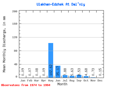
| Statistic | Jan | Feb | Mar | Apr | May | Jun | Jul | Aug | Sep | Oct | Nov | Dec | Annual |
|---|---|---|---|---|---|---|---|---|---|---|---|---|---|
| Mean | 0.09 | 0.07 | 0.08 | 0.09 | 102.61 | 35.17 | 7.88 | 5.62 | 8.53 | 4.68 | 0.73 | 0.15 | 164.19 |
| Standard Deviation | 0.33 | 0.30 | 0.34 | 0.33 | 39.01 | 22.69 | 10.59 | 7.75 | 10.53 | 5.91 | 1.20 | 0.35 | 53.44 |
| Min | 0.00 | 0.00 | 0.00 | 0.00 | 22.73 | 5.52 | 0.85 | 0.20 | 0.33 | 0.16 | 0.00 | 0.00 | 82.37 |
| Max | 1.35 | 1.23 | 1.38 | 1.37 | 182.82 | 72.24 | 45.16 | 26.75 | 30.66 | 17.03 | 3.79 | 1.38 | 267.71 |
| Coefficient of Variation | 3.73 | 4.12 | 4.12 | 3.59 | 0.38 | 0.65 | 1.34 | 1.38 | 1.23 | 1.26 | 1.64 | 2.36 | 0.33 |
 Return to R-Arctic Net Home Page