|
|
|||||||||||||||||
| Point ID: 6302 | Downloads | Plots | Site Data | Code: 3483 |
|
|
|||||||||||||||||
| Download | |
|---|---|
| Site Descriptor Information | Site Time Series Data |
| Link to all available data | |
| View: | Time Series | All |
| Units: | m3/s |
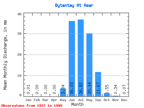
| Statistic | Jan | Feb | Mar | Apr | May | Jun | Jul | Aug | Sep | Oct | Nov | Dec | Annual |
|---|---|---|---|---|---|---|---|---|---|---|---|---|---|
| Mean | 0.01 | 0.00 | 0.00 | 0.00 | 3.84 | 36.03 | 36.81 | 30.14 | 11.68 | 1.55 | 0.34 | 0.07 | 120.69 |
| Standard Deviation | 0.01 | 0.00 | 0.00 | 0.00 | 3.99 | 17.94 | 16.70 | 14.41 | 6.25 | 0.66 | 0.15 | 0.06 | 39.89 |
| Min | 0.00 | 0.00 | 0.00 | 0.00 | 0.00 | 6.45 | 9.71 | 9.04 | 4.51 | 0.51 | 0.10 | 0.01 | 41.73 |
| Max | 0.08 | 0.01 | 0.00 | 0.00 | 17.07 | 92.02 | 76.99 | 65.68 | 30.39 | 3.62 | 1.00 | 0.32 | 251.08 |
| Coefficient of Variation | 2.56 | 6.69 | 1.04 | 0.50 | 0.45 | 0.48 | 0.54 | 0.42 | 0.45 | 0.89 | 0.33 |
 Return to R-Arctic Net Home Page