|
|
|||||||||||||||||
| Point ID: 6298 | Downloads | Plots | Site Data | Code: 3445 |
|
|
|||||||||||||||||
| Download | |
|---|---|
| Site Descriptor Information | Site Time Series Data |
| Link to all available data | |
| View: | Time Series | All |
| Units: | m3/s |
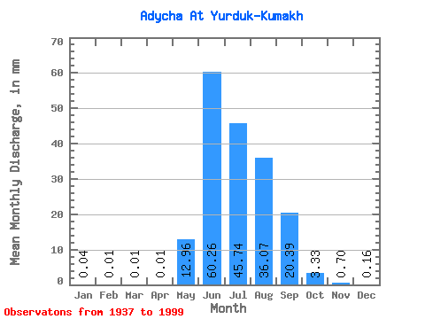
| Statistic | Jan | Feb | Mar | Apr | May | Jun | Jul | Aug | Sep | Oct | Nov | Dec | Annual |
|---|---|---|---|---|---|---|---|---|---|---|---|---|---|
| Mean | 0.04 | 0.01 | 0.01 | 0.01 | 12.96 | 60.26 | 45.73 | 36.06 | 20.39 | 3.33 | 0.70 | 0.16 | 180.52 |
| Standard Deviation | 0.03 | 0.01 | 0.01 | 0.02 | 10.46 | 24.56 | 15.54 | 16.23 | 11.20 | 1.62 | 0.28 | 0.09 | 44.72 |
| Min | 0.00 | 0.00 | 0.00 | 0.00 | 0.12 | 21.52 | 15.51 | 7.62 | 5.84 | 1.20 | 0.30 | 0.02 | 92.82 |
| Max | 0.11 | 0.06 | 0.05 | 0.06 | 66.05 | 161.13 | 95.94 | 84.28 | 66.25 | 9.74 | 1.55 | 0.50 | 360.53 |
| Coefficient of Variation | 0.74 | 1.39 | 2.04 | 1.80 | 0.81 | 0.41 | 0.34 | 0.45 | 0.55 | 0.49 | 0.39 | 0.56 | 0.25 |
 Return to R-Arctic Net Home Page