|
|
|||||||||||||||||
| Point ID: 6297 | Downloads | Plots | Site Data | Code: 3444 |
|
|
|||||||||||||||||
| Download | |
|---|---|
| Site Descriptor Information | Site Time Series Data |
| Link to all available data | |
| View: | Time Series | All |
| Units: | m3/s |
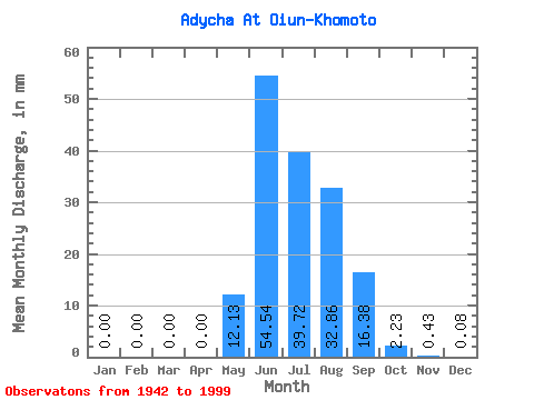
| Statistic | Jan | Feb | Mar | Apr | May | Jun | Jul | Aug | Sep | Oct | Nov | Dec | Annual |
|---|---|---|---|---|---|---|---|---|---|---|---|---|---|
| Mean | 0.00 | 0.00 | 0.00 | 0.00 | 12.13 | 54.54 | 39.71 | 32.85 | 16.38 | 2.23 | 0.43 | 0.08 | 157.93 |
| Standard Deviation | 0.01 | 0.00 | 0.00 | 0.00 | 9.91 | 21.30 | 15.90 | 17.25 | 10.73 | 1.38 | 0.19 | 0.06 | 38.27 |
| Min | 0.00 | 0.00 | 0.00 | 0.00 | 0.06 | 21.09 | 12.22 | 5.40 | 4.16 | 0.67 | 0.12 | 0.00 | 81.88 |
| Max | 0.03 | 0.01 | 0.00 | 0.00 | 57.24 | 127.03 | 99.35 | 84.63 | 56.98 | 7.65 | 0.88 | 0.28 | 253.94 |
| Coefficient of Variation | 1.37 | 4.70 | 7.21 | 0.82 | 0.39 | 0.40 | 0.53 | 0.66 | 0.62 | 0.45 | 0.78 | 0.24 |
 Return to R-Arctic Net Home Page