|
|
|||||||||||||||||
| Point ID: 6294 | Downloads | Plots | Site Data | Code: 3424 |
|
|
|||||||||||||||||
| Download | |
|---|---|
| Site Descriptor Information | Site Time Series Data |
| Link to all available data | |
| View: | Time Series | All |
| Units: | m3/s |
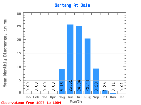
| Statistic | Jan | Feb | Mar | Apr | May | Jun | Jul | Aug | Sep | Oct | Nov | Dec | Annual |
|---|---|---|---|---|---|---|---|---|---|---|---|---|---|
| Mean | 0.00 | 0.00 | 0.00 | 0.00 | 9.18 | 25.51 | 24.84 | 20.43 | 9.29 | 1.26 | 0.11 | 0.01 | 90.29 |
| Standard Deviation | 0.00 | 0.00 | 0.00 | 0.00 | 7.38 | 14.40 | 13.12 | 10.81 | 5.68 | 0.80 | 0.07 | 0.01 | 32.01 |
| Min | 0.00 | 0.00 | 0.00 | 0.00 | 0.42 | 5.45 | 6.77 | 3.93 | 2.50 | 0.45 | 0.00 | 0.00 | 43.34 |
| Max | 0.01 | 0.00 | 0.00 | 0.00 | 32.87 | 61.93 | 72.64 | 49.23 | 30.73 | 4.73 | 0.28 | 0.06 | 169.73 |
| Coefficient of Variation | 6.08 | 0.81 | 0.56 | 0.53 | 0.53 | 0.61 | 0.63 | 0.68 | 1.56 | 0.35 |
 Return to R-Arctic Net Home Page