|
|
|||||||||||||||||
| Point ID: 6292 | Downloads | Plots | Site Data | Code: 3407 |
|
|
|||||||||||||||||
| Download | |
|---|---|
| Site Descriptor Information | Site Time Series Data |
| Link to all available data | |
| View: | Time Series | All |
| Units: | m3/s |
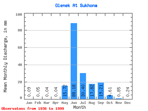
| Statistic | Jan | Feb | Mar | Apr | May | Jun | Jul | Aug | Sep | Oct | Nov | Dec | Annual |
|---|---|---|---|---|---|---|---|---|---|---|---|---|---|
| Mean | 0.09 | 0.05 | 0.04 | 0.04 | 15.72 | 88.18 | 30.40 | 17.82 | 19.21 | 4.61 | 0.85 | 0.24 | 177.63 |
| Standard Deviation | 0.05 | 0.03 | 0.03 | 0.03 | 20.03 | 25.80 | 19.60 | 13.07 | 11.10 | 3.16 | 0.58 | 0.13 | 44.62 |
| Min | 0.02 | 0.00 | 0.00 | 0.00 | 0.02 | 35.72 | 2.81 | 1.64 | 1.91 | 0.49 | 0.14 | 0.06 | 73.59 |
| Max | 0.24 | 0.18 | 0.17 | 0.17 | 77.39 | 146.74 | 108.39 | 56.30 | 52.45 | 15.60 | 4.45 | 0.67 | 311.10 |
| Coefficient of Variation | 0.51 | 0.67 | 0.82 | 0.82 | 1.27 | 0.29 | 0.65 | 0.73 | 0.58 | 0.69 | 0.68 | 0.55 | 0.25 |
 Return to R-Arctic Net Home Page