|
|
|||||||||||||||||
| Point ID: 6289 | Downloads | Plots | Site Data | Code: 3403 |
|
|
|||||||||||||||||
| Download | |
|---|---|
| Site Descriptor Information | Site Time Series Data |
| Link to all available data | |
| View: | Time Series | All |
| Units: | m3/s |
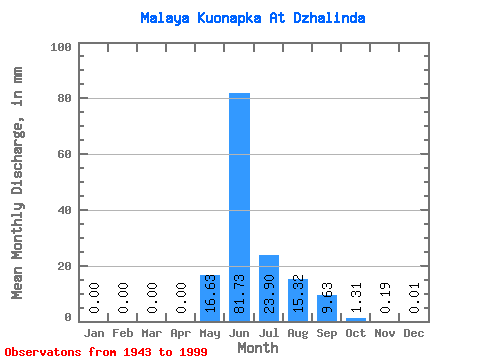
| Statistic | Jan | Feb | Mar | Apr | May | Jun | Jul | Aug | Sep | Oct | Nov | Dec | Annual |
|---|---|---|---|---|---|---|---|---|---|---|---|---|---|
| Mean | 0.00 | 0.00 | 0.00 | 0.00 | 16.63 | 81.73 | 23.90 | 15.31 | 9.63 | 1.31 | 0.19 | 0.01 | 149.03 |
| Standard Deviation | 0.00 | 0.00 | 0.00 | 0.00 | 23.13 | 32.97 | 20.71 | 17.91 | 11.47 | 1.52 | 0.51 | 0.04 | 56.90 |
| Min | 0.00 | 0.00 | 0.00 | 0.00 | 0.00 | 14.56 | 0.36 | 0.24 | 0.25 | 0.01 | 0.00 | 0.00 | 47.60 |
| Max | 0.00 | 0.00 | 0.00 | 0.00 | 88.25 | 146.84 | 70.05 | 87.46 | 73.16 | 7.47 | 3.22 | 0.20 | 356.68 |
| Coefficient of Variation | 1.39 | 0.40 | 0.87 | 1.17 | 1.19 | 1.16 | 2.63 | 4.27 | 0.38 |
 Return to R-Arctic Net Home Page