|
|
|||||||||||||||||
| Point ID: 6288 | Downloads | Plots | Site Data | Code: 3397 |
|
|
|||||||||||||||||
| Download | |
|---|---|
| Site Descriptor Information | Site Time Series Data |
| Link to all available data | |
| View: | Time Series | All |
| Units: | m3/s |
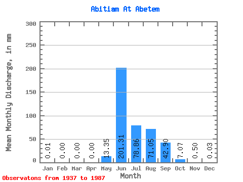
| Statistic | Jan | Feb | Mar | Apr | May | Jun | Jul | Aug | Sep | Oct | Nov | Dec | Annual |
|---|---|---|---|---|---|---|---|---|---|---|---|---|---|
| Mean | 0.01 | 0.00 | 0.00 | 0.00 | 13.35 | 201.31 | 78.85 | 71.04 | 42.90 | 7.07 | 0.50 | 0.03 | 416.75 |
| Standard Deviation | 0.03 | 0.00 | 0.00 | 0.00 | 19.11 | 72.85 | 42.99 | 36.22 | 29.05 | 10.68 | 1.11 | 0.09 | 108.20 |
| Min | 0.00 | 0.00 | 0.00 | 0.00 | 0.00 | 71.54 | 19.42 | 16.90 | 4.20 | 0.09 | 0.00 | 0.00 | 194.38 |
| Max | 0.14 | 0.03 | 0.00 | 0.00 | 87.84 | 378.43 | 205.40 | 163.89 | 124.16 | 51.15 | 7.57 | 0.35 | 617.00 |
| Coefficient of Variation | 4.23 | 6.00 | 7.00 | 1.43 | 0.36 | 0.55 | 0.51 | 0.68 | 1.51 | 2.24 | 2.64 | 0.26 |
 Return to R-Arctic Net Home Page