|
|
|||||||||||||||||
| Point ID: 6287 | Downloads | Plots | Site Data | Code: 3394 |
|
|
|||||||||||||||||
| Download | |
|---|---|
| Site Descriptor Information | Site Time Series Data |
| Link to all available data | |
| View: | Time Series | All |
| Units: | m3/s |
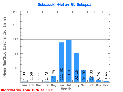
| Statistic | Jan | Feb | Mar | Apr | May | Jun | Jul | Aug | Sep | Oct | Nov | Dec | Annual |
|---|---|---|---|---|---|---|---|---|---|---|---|---|---|
| Mean | 1.90 | 1.10 | 1.11 | 1.73 | 17.79 | 111.82 | 118.30 | 82.15 | 34.92 | 12.93 | 6.26 | 3.46 | 366.70 |
| Standard Deviation | 1.92 | 1.17 | 1.45 | 1.45 | 14.79 | 43.40 | 42.37 | 41.23 | 17.43 | 5.59 | 4.65 | 3.44 | 94.57 |
| Min | 0.47 | 0.33 | 0.19 | 0.61 | 4.19 | 34.37 | 58.92 | 33.88 | 14.33 | 2.80 | 0.57 | 0.47 | 242.79 |
| Max | 7.97 | 4.75 | 5.70 | 6.21 | 53.26 | 172.92 | 217.56 | 154.49 | 67.63 | 27.50 | 20.84 | 14.01 | 538.80 |
| Coefficient of Variation | 1.01 | 1.06 | 1.31 | 0.84 | 0.83 | 0.39 | 0.36 | 0.50 | 0.50 | 0.43 | 0.74 | 0.99 | 0.26 |
 Return to R-Arctic Net Home Page