|
|
|||||||||||||||||
| Point ID: 6282 | Downloads | Plots | Site Data | Code: 3383 |
|
|
|||||||||||||||||
| Download | |
|---|---|
| Site Descriptor Information | Site Time Series Data |
| Link to all available data | |
| View: | Time Series | All |
| Units: | m3/s |
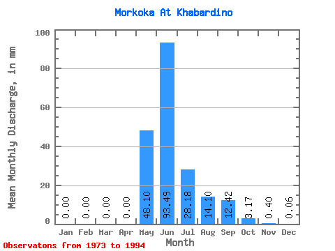
| Statistic | Jan | Feb | Mar | Apr | May | Jun | Jul | Aug | Sep | Oct | Nov | Dec | Annual |
|---|---|---|---|---|---|---|---|---|---|---|---|---|---|
| Mean | 0.00 | 0.00 | 0.00 | 0.00 | 48.09 | 93.49 | 28.18 | 14.10 | 12.42 | 3.17 | 0.40 | 0.06 | 197.23 |
| Standard Deviation | 0.01 | 0.00 | 0.00 | 0.00 | 36.49 | 37.80 | 23.99 | 14.10 | 8.67 | 2.20 | 0.38 | 0.05 | 49.66 |
| Min | 0.00 | 0.00 | 0.00 | 0.00 | 1.09 | 46.68 | 2.59 | 1.18 | 2.65 | 0.55 | 0.08 | 0.00 | 128.44 |
| Max | 0.02 | 0.00 | 0.00 | 0.00 | 152.62 | 156.08 | 91.43 | 47.51 | 33.45 | 8.54 | 1.67 | 0.18 | 298.51 |
| Coefficient of Variation | 1.59 | 4.36 | 0.76 | 0.40 | 0.85 | 1.00 | 0.70 | 0.69 | 0.94 | 0.81 | 0.25 |
 Return to R-Arctic Net Home Page