|
|
|||||||||||||||||
| Point ID: 6280 | Downloads | Plots | Site Data | Code: 3367 |
|
|
|||||||||||||||||
| Download | |
|---|---|
| Site Descriptor Information | Site Time Series Data |
| Link to all available data | |
| View: | Time Series | All |
| Units: | m3/s |
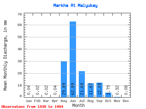
| Statistic | Jan | Feb | Mar | Apr | May | Jun | Jul | Aug | Sep | Oct | Nov | Dec | Annual |
|---|---|---|---|---|---|---|---|---|---|---|---|---|---|
| Mean | 0.04 | 0.02 | 0.02 | 0.04 | 29.89 | 62.89 | 21.62 | 11.67 | 12.09 | 3.79 | 0.32 | 0.08 | 142.82 |
| Standard Deviation | 0.03 | 0.03 | 0.02 | 0.15 | 21.61 | 22.53 | 17.02 | 12.98 | 8.76 | 2.54 | 0.17 | 0.06 | 42.59 |
| Min | 0.00 | 0.00 | 0.00 | 0.00 | 0.13 | 20.57 | 2.63 | 0.40 | 0.76 | 0.43 | 0.02 | 0.00 | 68.22 |
| Max | 0.10 | 0.09 | 0.08 | 1.08 | 101.62 | 113.69 | 78.01 | 71.43 | 34.14 | 10.82 | 0.74 | 0.27 | 252.76 |
| Coefficient of Variation | 0.87 | 1.24 | 1.27 | 4.03 | 0.72 | 0.36 | 0.79 | 1.11 | 0.72 | 0.67 | 0.54 | 0.65 | 0.30 |
 Return to R-Arctic Net Home Page