|
|
|||||||||||||||||
| Point ID: 6277 | Downloads | Plots | Site Data | Code: 3362 |
|
|
|||||||||||||||||
| Download | |
|---|---|
| Site Descriptor Information | Site Time Series Data |
| Link to all available data | |
| View: | Time Series | All |
| Units: | m3/s |
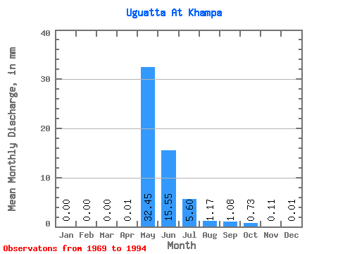
| Statistic | Jan | Feb | Mar | Apr | May | Jun | Jul | Aug | Sep | Oct | Nov | Dec | Annual |
|---|---|---|---|---|---|---|---|---|---|---|---|---|---|
| Mean | 0.00 | 0.00 | 0.00 | 0.01 | 32.44 | 15.55 | 5.60 | 1.17 | 1.08 | 0.73 | 0.12 | 0.01 | 56.32 |
| Standard Deviation | 0.00 | 0.00 | 0.00 | 0.02 | 30.27 | 13.37 | 8.92 | 1.75 | 2.14 | 1.29 | 0.18 | 0.02 | 42.61 |
| Min | 0.00 | 0.00 | 0.00 | 0.00 | 7.12 | 0.00 | 0.38 | 0.09 | 0.03 | 0.02 | 0.00 | 0.00 | 10.28 |
| Max | 0.00 | 0.00 | 0.00 | 0.09 | 154.46 | 56.70 | 39.69 | 7.17 | 8.77 | 4.28 | 0.58 | 0.10 | 182.87 |
| Coefficient of Variation | 3.75 | 0.93 | 0.86 | 1.59 | 1.50 | 1.98 | 1.77 | 1.59 | 2.73 | 0.76 |
 Return to R-Arctic Net Home Page