|
|
|||||||||||||||||
| Point ID: 6267 | Downloads | Plots | Site Data | Code: 3332 |
|
|
|||||||||||||||||
| Download | |
|---|---|
| Site Descriptor Information | Site Time Series Data |
| Link to all available data | |
| View: | Time Series | All |
| Units: | m3/s |
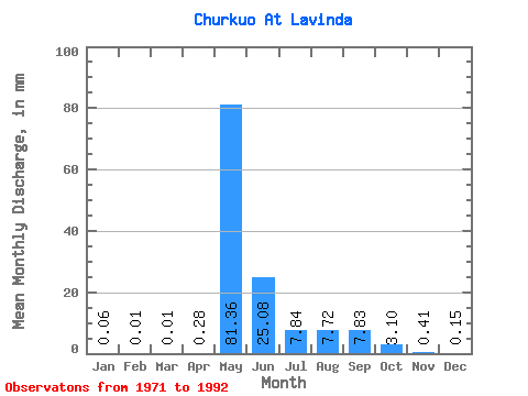
| Statistic | Jan | Feb | Mar | Apr | May | Jun | Jul | Aug | Sep | Oct | Nov | Dec | Annual |
|---|---|---|---|---|---|---|---|---|---|---|---|---|---|
| Mean | 0.06 | 0.01 | 0.01 | 0.28 | 81.35 | 25.08 | 7.84 | 7.72 | 7.83 | 3.10 | 0.41 | 0.15 | 166.20 |
| Standard Deviation | 0.06 | 0.01 | 0.01 | 0.38 | 27.13 | 16.34 | 11.46 | 9.78 | 8.69 | 2.88 | 0.48 | 0.13 | 2.68 |
| Min | 0.00 | 0.00 | 0.00 | 0.00 | 40.07 | 2.48 | 0.73 | 0.16 | 0.13 | 0.14 | 0.07 | 0.01 | 164.31 |
| Max | 0.21 | 0.04 | 0.01 | 0.93 | 140.06 | 52.22 | 38.58 | 34.50 | 29.31 | 8.88 | 2.04 | 0.45 | 168.09 |
| Coefficient of Variation | 1.03 | 1.38 | 1.10 | 1.37 | 0.33 | 0.65 | 1.46 | 1.27 | 1.11 | 0.93 | 1.19 | 0.89 | 0.02 |
 Return to R-Arctic Net Home Page