|
|
|||||||||||||||||
| Point ID: 6265 | Downloads | Plots | Site Data | Code: 3321 |
|
|
|||||||||||||||||
| Download | |
|---|---|
| Site Descriptor Information | Site Time Series Data |
| Link to all available data | |
| View: | Time Series | All |
| Units: | m3/s |
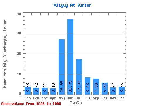
| Statistic | Jan | Feb | Mar | Apr | May | Jun | Jul | Aug | Sep | Oct | Nov | Dec | Annual |
|---|---|---|---|---|---|---|---|---|---|---|---|---|---|
| Mean | 3.88 | 3.45 | 3.41 | 3.10 | 26.95 | 36.75 | 17.33 | 8.43 | 7.88 | 5.82 | 3.47 | 3.95 | 123.04 |
| Standard Deviation | 5.00 | 4.44 | 4.41 | 4.20 | 13.60 | 23.19 | 9.19 | 6.90 | 5.55 | 3.75 | 3.29 | 4.71 | 35.16 |
| Min | 0.03 | 0.01 | 0.01 | 0.01 | 3.81 | 8.08 | 3.46 | 0.18 | 1.20 | 0.53 | 0.17 | 0.07 | 60.09 |
| Max | 13.22 | 11.64 | 12.13 | 17.19 | 57.80 | 106.89 | 48.12 | 36.33 | 24.51 | 22.27 | 10.28 | 12.50 | 230.31 |
| Coefficient of Variation | 1.29 | 1.29 | 1.29 | 1.36 | 0.51 | 0.63 | 0.53 | 0.82 | 0.70 | 0.64 | 0.95 | 1.19 | 0.29 |
 Return to R-Arctic Net Home Page