|
|
|||||||||||||||||
| Point ID: 6264 | Downloads | Plots | Site Data | Code: 3315 |
|
|
|||||||||||||||||
| Download | |
|---|---|
| Site Descriptor Information | Site Time Series Data |
| Link to all available data | |
| View: | Time Series | All |
| Units: | m3/s |
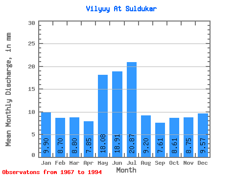
| Statistic | Jan | Feb | Mar | Apr | May | Jun | Jul | Aug | Sep | Oct | Nov | Dec | Annual |
|---|---|---|---|---|---|---|---|---|---|---|---|---|---|
| Mean | 9.90 | 8.77 | 8.80 | 7.85 | 18.07 | 18.91 | 20.87 | 9.20 | 7.61 | 8.61 | 8.75 | 9.56 | 132.64 |
| Standard Deviation | 4.40 | 3.73 | 3.76 | 4.54 | 7.54 | 10.10 | 11.14 | 9.67 | 6.26 | 4.50 | 3.96 | 3.86 | 40.07 |
| Min | 0.02 | 0.00 | 0.00 | 0.52 | 8.81 | 8.55 | 3.16 | 0.14 | 1.50 | 0.99 | 0.60 | 0.46 | 62.09 |
| Max | 15.11 | 13.55 | 13.28 | 22.99 | 38.73 | 40.58 | 43.04 | 40.33 | 29.31 | 23.75 | 17.28 | 14.14 | 245.47 |
| Coefficient of Variation | 0.44 | 0.42 | 0.43 | 0.58 | 0.42 | 0.53 | 0.53 | 1.05 | 0.82 | 0.52 | 0.45 | 0.40 | 0.30 |
 Return to R-Arctic Net Home Page