|
|
|||||||||||||||||
| Point ID: 6262 | Downloads | Plots | Site Data | Code: 3310 |
|
|
|||||||||||||||||
| Download | |
|---|---|
| Site Descriptor Information | Site Time Series Data |
| Link to all available data | |
| View: | Time Series | All |
| Units: | m3/s |
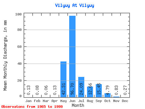
| Statistic | Jan | Feb | Mar | Apr | May | Jun | Jul | Aug | Sep | Oct | Nov | Dec | Annual |
|---|---|---|---|---|---|---|---|---|---|---|---|---|---|
| Mean | 0.13 | 0.08 | 0.06 | 0.13 | 42.30 | 96.70 | 24.09 | 12.66 | 15.45 | 4.79 | 0.83 | 0.27 | 201.33 |
| Standard Deviation | 0.14 | 0.10 | 0.08 | 0.53 | 32.73 | 40.11 | 15.95 | 14.14 | 11.33 | 3.88 | 0.82 | 0.28 | 46.21 |
| Min | 0.02 | 0.00 | 0.01 | 0.01 | 1.27 | 30.13 | 2.11 | 0.99 | 1.04 | 0.68 | 0.16 | 0.03 | 114.95 |
| Max | 0.53 | 0.34 | 0.29 | 3.00 | 147.22 | 216.23 | 80.85 | 51.41 | 46.59 | 19.11 | 3.71 | 1.15 | 306.64 |
| Coefficient of Variation | 1.07 | 1.23 | 1.27 | 3.96 | 0.77 | 0.41 | 0.66 | 1.12 | 0.73 | 0.81 | 0.98 | 1.04 | 0.23 |
 Return to R-Arctic Net Home Page