|
|
|||||||||||||||||
| Point ID: 6258 | Downloads | Plots | Site Data | Code: 3295 |
|
|
|||||||||||||||||
| Download | |
|---|---|
| Site Descriptor Information | Site Time Series Data |
| Link to all available data | |
| View: | Time Series | All |
| Units: | m3/s |
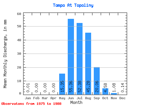
| Statistic | Jan | Feb | Mar | Apr | May | Jun | Jul | Aug | Sep | Oct | Nov | Dec | Annual |
|---|---|---|---|---|---|---|---|---|---|---|---|---|---|
| Mean | 0.01 | 0.00 | 0.00 | 0.00 | 15.35 | 55.36 | 52.38 | 45.27 | 20.06 | 4.58 | 1.08 | 0.14 | 196.29 |
| Standard Deviation | 0.04 | 0.00 | 0.00 | 0.00 | 11.10 | 17.32 | 21.17 | 14.78 | 9.35 | 2.44 | 1.06 | 0.35 | 38.53 |
| Min | 0.00 | 0.00 | 0.00 | 0.00 | 0.96 | 23.38 | 26.15 | 20.27 | 8.70 | 1.42 | 0.01 | 0.00 | 144.16 |
| Max | 0.14 | 0.00 | 0.00 | 0.00 | 41.48 | 85.69 | 99.14 | 68.26 | 42.28 | 9.58 | 3.63 | 1.25 | 300.08 |
| Coefficient of Variation | 3.50 | 3.61 | 0.72 | 0.31 | 0.40 | 0.33 | 0.47 | 0.53 | 0.97 | 2.48 | 0.20 |
 Return to R-Arctic Net Home Page