|
|
|||||||||||||||||
| Point ID: 6249 | Downloads | Plots | Site Data | Code: 3275 |
|
|
|||||||||||||||||
| Download | |
|---|---|
| Site Descriptor Information | Site Time Series Data |
| Link to all available data | |
| View: | Time Series | All |
| Units: | m3/s |
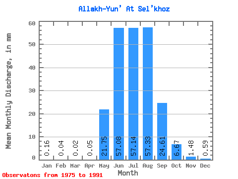
| Statistic | Jan | Feb | Mar | Apr | May | Jun | Jul | Aug | Sep | Oct | Nov | Dec | Annual |
|---|---|---|---|---|---|---|---|---|---|---|---|---|---|
| Mean | 0.16 | 0.04 | 0.02 | 0.06 | 21.75 | 57.08 | 57.13 | 57.32 | 24.61 | 6.67 | 1.48 | 0.59 | 210.10 |
| Standard Deviation | 0.32 | 0.08 | 0.06 | 0.14 | 12.12 | 38.32 | 22.53 | 35.96 | 11.20 | 7.48 | 1.46 | 0.86 | 66.51 |
| Min | 0.00 | 0.00 | 0.00 | 0.00 | 9.23 | 4.84 | 27.85 | 17.64 | 6.24 | 0.13 | 0.01 | 0.00 | 137.05 |
| Max | 1.15 | 0.24 | 0.19 | 0.51 | 50.17 | 150.85 | 103.37 | 129.62 | 47.17 | 26.60 | 4.58 | 2.84 | 293.99 |
| Coefficient of Variation | 2.01 | 2.17 | 3.13 | 2.65 | 0.56 | 0.67 | 0.39 | 0.63 | 0.46 | 1.12 | 0.99 | 1.45 | 0.32 |
 Return to R-Arctic Net Home Page