|
|
|||||||||||||||||
| Point ID: 6242 | Downloads | Plots | Site Data | Code: 3248 |
|
|
|||||||||||||||||
| Download | |
|---|---|
| Site Descriptor Information | Site Time Series Data |
| Link to all available data | |
| View: | Time Series | All |
| Units: | m3/s |
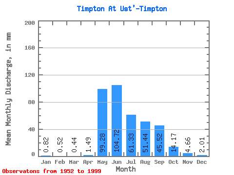
| Statistic | Jan | Feb | Mar | Apr | May | Jun | Jul | Aug | Sep | Oct | Nov | Dec | Annual |
|---|---|---|---|---|---|---|---|---|---|---|---|---|---|
| Mean | 0.81 | 0.53 | 0.44 | 1.50 | 99.27 | 104.72 | 61.32 | 51.43 | 45.52 | 14.17 | 4.66 | 2.01 | 384.32 |
| Standard Deviation | 0.57 | 0.43 | 0.34 | 2.82 | 36.65 | 44.62 | 33.54 | 28.59 | 19.26 | 5.72 | 2.20 | 1.22 | 77.39 |
| Min | 0.09 | 0.04 | 0.07 | 0.11 | 29.72 | 42.23 | 13.60 | 11.09 | 15.54 | 4.31 | 1.26 | 0.47 | 222.82 |
| Max | 2.54 | 2.31 | 1.48 | 14.53 | 188.19 | 201.07 | 163.01 | 128.08 | 93.72 | 30.15 | 9.61 | 5.17 | 623.04 |
| Coefficient of Variation | 0.69 | 0.82 | 0.79 | 1.89 | 0.37 | 0.43 | 0.55 | 0.56 | 0.42 | 0.40 | 0.47 | 0.61 | 0.20 |
 Return to R-Arctic Net Home Page