|
|
|||||||||||||||||
| Point ID: 6231 | Downloads | Plots | Site Data | Code: 3218 |
|
|
|||||||||||||||||
| Download | |
|---|---|
| Site Descriptor Information | Site Time Series Data |
| Link to all available data | |
| View: | Time Series | All |
| Units: | m3/s |
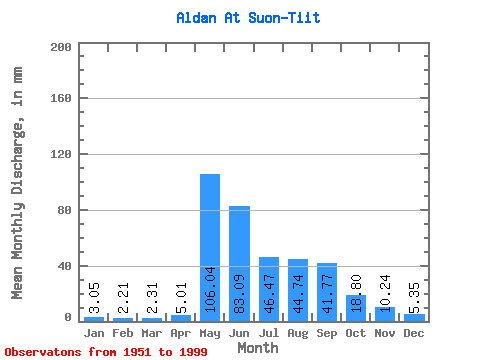
| Statistic | Jan | Feb | Mar | Apr | May | Jun | Jul | Aug | Sep | Oct | Nov | Dec | Annual |
|---|---|---|---|---|---|---|---|---|---|---|---|---|---|
| Mean | 3.04 | 2.23 | 2.31 | 5.01 | 106.03 | 83.09 | 46.46 | 44.73 | 41.77 | 18.80 | 10.24 | 5.35 | 367.23 |
| Standard Deviation | 1.38 | 1.07 | 1.35 | 5.29 | 28.40 | 35.33 | 24.63 | 21.85 | 17.61 | 7.12 | 5.74 | 2.81 | 73.78 |
| Min | 1.05 | 0.20 | 0.15 | 0.98 | 42.85 | 37.83 | 13.59 | 13.29 | 15.13 | 4.66 | 3.66 | 1.65 | 190.38 |
| Max | 6.83 | 5.45 | 7.18 | 26.90 | 176.60 | 182.14 | 150.55 | 91.34 | 82.38 | 37.64 | 26.90 | 13.59 | 559.07 |
| Coefficient of Variation | 0.45 | 0.48 | 0.58 | 1.06 | 0.27 | 0.42 | 0.53 | 0.49 | 0.42 | 0.38 | 0.56 | 0.53 | 0.20 |
 Return to R-Arctic Net Home Page