|
|
|||||||||||||||||
| Point ID: 623 | Downloads | Plots | Site Data | Code: 07AF014 |
|
|
|||||||||||||||||
| Download | |
|---|---|
| Site Descriptor Information | Site Time Series Data |
| Link to all available data | |
| View: | Time Series | All |
| Units: | m3/s |
| Statistic | Jan | Feb | Mar | Apr | May | Jun | Jul | Aug | Sep | Oct | Nov | Dec | Annual |
|---|---|---|---|---|---|---|---|---|---|---|---|---|---|
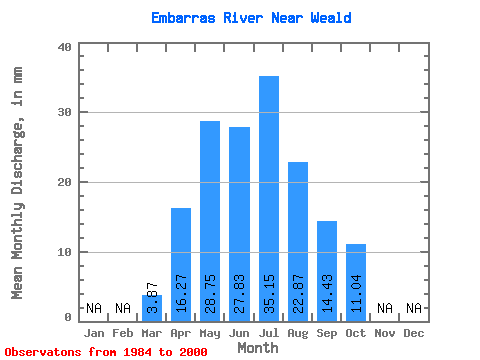
| Mean | 3.87 | 16.27 | 28.75 | 27.84 | 35.14 | 22.87 | 14.43 | 11.04 | |||||
| Standard Deviation | 2.91 | 8.59 | 19.40 | 17.98 | 28.75 | 21.98 | 8.81 | 6.88 | |||||
| Min | 1.64 | 6.37 | 6.33 | 5.69 | 5.96 | 3.32 | 4.53 | 3.88 | |||||
| Max | 14.20 | 33.05 | 65.40 | 66.90 | 108.03 | 79.89 | 33.01 | 31.46 | |||||
| Coefficient of Variation | 0.75 | 0.53 | 0.68 | 0.65 | 0.82 | 0.96 | 0.61 | 0.62 |
 Return to R-Arctic Net Home Page