|
|
|||||||||||||||||
| Point ID: 6228 | Downloads | Plots | Site Data | Code: 3210 |
|
|
|||||||||||||||||
| Download | |
|---|---|
| Site Descriptor Information | Site Time Series Data |
| Link to all available data | |
| View: | Time Series | All |
| Units: | m3/s |
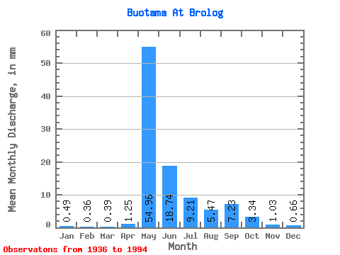
| Statistic | Jan | Feb | Mar | Apr | May | Jun | Jul | Aug | Sep | Oct | Nov | Dec | Annual |
|---|---|---|---|---|---|---|---|---|---|---|---|---|---|
| Mean | 0.49 | 0.37 | 0.39 | 1.25 | 54.95 | 18.74 | 9.21 | 5.47 | 7.23 | 3.34 | 1.02 | 0.66 | 102.71 |
| Standard Deviation | 0.25 | 0.17 | 0.17 | 3.03 | 20.27 | 12.47 | 8.42 | 4.36 | 8.91 | 3.06 | 0.65 | 0.36 | 33.67 |
| Min | 0.05 | 0.11 | 0.09 | 0.15 | 15.98 | 3.61 | 1.05 | 0.70 | 0.59 | 0.38 | 0.15 | 0.09 | 23.00 |
| Max | 1.25 | 0.83 | 0.94 | 14.89 | 99.88 | 66.50 | 47.19 | 18.83 | 50.35 | 16.53 | 3.61 | 1.95 | 191.80 |
| Coefficient of Variation | 0.50 | 0.46 | 0.43 | 2.43 | 0.37 | 0.67 | 0.91 | 0.80 | 1.23 | 0.92 | 0.64 | 0.54 | 0.33 |
 Return to R-Arctic Net Home Page