|
|
|||||||||||||||||
| Point ID: 622 | Downloads | Plots | Site Data | Code: 07AF013 |
|
|
|||||||||||||||||
| Download | |
|---|---|
| Site Descriptor Information | Site Time Series Data |
| Link to all available data | |
| View: | Time Series | All |
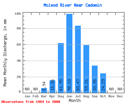
| Units: | m3/s |
| Statistic | Jan | Feb | Mar | Apr | May | Jun | Jul | Aug | Sep | Oct | Nov | Dec | Annual |
|---|---|---|---|---|---|---|---|---|---|---|---|---|---|
| Mean | 5.94 | 15.56 | 61.95 | 98.03 | 83.45 | 59.30 | 33.95 | 24.29 | |||||
| Standard Deviation | 2.24 | 6.96 | 30.16 | 39.92 | 52.16 | 37.23 | 16.57 | 11.50 | |||||
| Min | 3.58 | 7.19 | 25.81 | 34.38 | 22.01 | 17.07 | 16.05 | 12.38 | |||||
| Max | 12.22 | 33.59 | 135.11 | 197.34 | 233.82 | 139.97 | 71.81 | 57.60 | |||||
| Coefficient of Variation | 0.38 | 0.45 | 0.49 | 0.41 | 0.62 | 0.63 | 0.49 | 0.47 |
 Return to R-Arctic Net Home Page