|
|
|||||||||||||||||
| Point ID: 6211 | Downloads | Plots | Site Data | Code: 3158 |
|
|
|||||||||||||||||
| Download | |
|---|---|
| Site Descriptor Information | Site Time Series Data |
| Link to all available data | |
| View: | Time Series | All |
| Units: | m3/s |
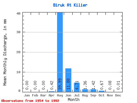
| Statistic | Jan | Feb | Mar | Apr | May | Jun | Jul | Aug | Sep | Oct | Nov | Dec | Annual |
|---|---|---|---|---|---|---|---|---|---|---|---|---|---|
| Mean | 0.00 | 0.00 | 0.00 | 0.42 | 39.98 | 11.88 | 4.71 | 1.35 | 1.42 | 0.67 | 0.08 | 0.01 | 62.27 |
| Standard Deviation | 0.00 | 0.00 | 0.00 | 1.09 | 28.88 | 8.63 | 9.57 | 2.74 | 2.17 | 0.90 | 0.10 | 0.02 | 41.53 |
| Min | 0.00 | 0.00 | 0.00 | 0.00 | 3.62 | 1.89 | 0.30 | 0.01 | 0.07 | 0.01 | 0.00 | 0.00 | 10.92 |
| Max | 0.00 | 0.00 | 0.00 | 5.10 | 113.77 | 38.78 | 56.78 | 14.40 | 8.74 | 3.94 | 0.37 | 0.11 | 201.50 |
| Coefficient of Variation | 2.58 | 0.72 | 0.73 | 2.03 | 2.02 | 1.53 | 1.35 | 1.28 | 3.31 | 0.67 |
 Return to R-Arctic Net Home Page