|
|
|||||||||||||||||
| Point ID: 6194 | Downloads | Plots | Site Data | Code: 3133 |
|
|
|||||||||||||||||
| Download | |
|---|---|
| Site Descriptor Information | Site Time Series Data |
| Link to all available data | |
| View: | Time Series | All |
| Units: | m3/s |
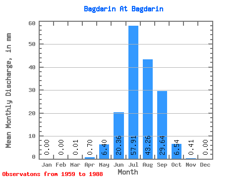
| Statistic | Jan | Feb | Mar | Apr | May | Jun | Jul | Aug | Sep | Oct | Nov | Dec | Annual |
|---|---|---|---|---|---|---|---|---|---|---|---|---|---|
| Mean | 0.00 | 0.00 | 0.01 | 0.70 | 6.40 | 20.36 | 57.90 | 43.25 | 29.64 | 6.54 | 0.41 | 0.00 | 163.92 |
| Standard Deviation | 0.00 | 0.00 | 0.03 | 0.66 | 6.67 | 24.08 | 67.35 | 40.40 | 35.44 | 3.53 | 0.47 | 0.00 | 106.44 |
| Min | 0.00 | 0.00 | 0.00 | 0.00 | 1.15 | 0.88 | 0.69 | 2.77 | 1.20 | 0.85 | 0.00 | 0.00 | 16.08 |
| Max | 0.00 | 0.00 | 0.12 | 3.06 | 24.87 | 114.79 | 247.72 | 141.55 | 151.82 | 14.25 | 1.94 | 0.00 | 357.26 |
| Coefficient of Variation | 3.47 | 0.94 | 1.04 | 1.18 | 1.16 | 0.93 | 1.20 | 0.54 | 1.16 | 0.65 |
 Return to R-Arctic Net Home Page