|
|
|||||||||||||||||
| Point ID: 6191 | Downloads | Plots | Site Data | Code: 3130 |
|
|
|||||||||||||||||
| Download | |
|---|---|
| Site Descriptor Information | Site Time Series Data |
| Link to all available data | |
| View: | Time Series | All |
| Units: | m3/s |
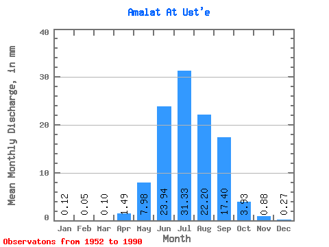
| Statistic | Jan | Feb | Mar | Apr | May | Jun | Jul | Aug | Sep | Oct | Nov | Dec | Annual |
|---|---|---|---|---|---|---|---|---|---|---|---|---|---|
| Mean | 0.12 | 0.05 | 0.10 | 1.49 | 7.97 | 23.94 | 31.32 | 22.20 | 17.40 | 3.93 | 0.88 | 0.27 | 109.14 |
| Standard Deviation | 0.24 | 0.11 | 0.15 | 1.04 | 6.62 | 27.93 | 34.39 | 21.70 | 19.95 | 2.15 | 0.42 | 0.30 | 64.69 |
| Min | 0.00 | 0.00 | 0.00 | 0.03 | 0.83 | 4.60 | 2.81 | 2.54 | 2.05 | 1.67 | 0.05 | 0.00 | 19.53 |
| Max | 1.05 | 0.51 | 0.64 | 4.06 | 41.57 | 140.71 | 154.30 | 62.61 | 88.87 | 12.88 | 1.96 | 1.06 | 275.27 |
| Coefficient of Variation | 2.04 | 2.17 | 1.56 | 0.70 | 0.83 | 1.17 | 1.10 | 0.98 | 1.15 | 0.55 | 0.48 | 1.14 | 0.59 |
 Return to R-Arctic Net Home Page