|
|
|||||||||||||||||
| Point ID: 6187 | Downloads | Plots | Site Data | Code: 3124 |
|
|
|||||||||||||||||
| Download | |
|---|---|
| Site Descriptor Information | Site Time Series Data |
| Link to all available data | |
| View: | Time Series | All |
| Units: | m3/s |
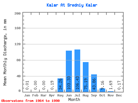
| Statistic | Jan | Feb | Mar | Apr | May | Jun | Jul | Aug | Sep | Oct | Nov | Dec | Annual |
|---|---|---|---|---|---|---|---|---|---|---|---|---|---|
| Mean | 0.01 | 0.00 | 0.00 | 0.19 | 34.26 | 103.33 | 106.41 | 75.18 | 43.86 | 9.15 | 1.69 | 0.17 | 370.82 |
| Standard Deviation | 0.03 | 0.00 | 0.00 | 0.37 | 27.16 | 49.49 | 52.79 | 38.88 | 22.68 | 4.20 | 1.19 | 0.18 | 109.38 |
| Min | 0.00 | 0.00 | 0.00 | 0.00 | 1.91 | 7.57 | 29.32 | 15.32 | 18.37 | 3.34 | 0.29 | 0.00 | 182.22 |
| Max | 0.13 | 0.00 | 0.00 | 1.46 | 107.31 | 194.87 | 256.07 | 172.80 | 92.71 | 21.11 | 5.98 | 0.64 | 629.40 |
| Coefficient of Variation | 4.59 | 1.89 | 0.79 | 0.48 | 0.50 | 0.52 | 0.52 | 0.46 | 0.70 | 1.05 | 0.29 |
 Return to R-Arctic Net Home Page