|
|
|||||||||||||||||
| Point ID: 6178 | Downloads | Plots | Site Data | Code: 3110 |
|
|
|||||||||||||||||
| Download | |
|---|---|
| Site Descriptor Information | Site Time Series Data |
| Link to all available data | |
| View: | Time Series | All |
| Units: | m3/s |
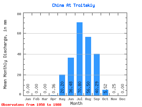
| Statistic | Jan | Feb | Mar | Apr | May | Jun | Jul | Aug | Sep | Oct | Nov | Dec | Annual |
|---|---|---|---|---|---|---|---|---|---|---|---|---|---|
| Mean | 0.00 | 0.00 | 0.00 | 0.36 | 20.20 | 36.48 | 70.79 | 56.49 | 40.29 | 5.52 | 0.25 | 0.00 | 228.56 |
| Standard Deviation | 0.00 | 0.00 | 0.00 | 0.85 | 18.56 | 29.31 | 72.13 | 54.34 | 58.12 | 7.66 | 0.79 | 0.00 | 154.20 |
| Min | 0.00 | 0.00 | 0.00 | 0.00 | 0.41 | 1.56 | 4.18 | 4.66 | 1.68 | 0.55 | 0.00 | 0.00 | 36.07 |
| Max | 0.00 | 0.00 | 0.00 | 4.22 | 67.55 | 110.51 | 287.53 | 233.73 | 298.54 | 37.84 | 4.28 | 0.00 | 803.24 |
| Coefficient of Variation | 2.34 | 0.92 | 0.80 | 1.02 | 0.96 | 1.44 | 1.39 | 3.17 | 0.68 |
 Return to R-Arctic Net Home Page