|
|
|||||||||||||||||
| Point ID: 617 | Downloads | Plots | Site Data | Code: 07AF008 |
|
|
|||||||||||||||||
| Download | |
|---|---|
| Site Descriptor Information | Site Time Series Data |
| Link to all available data | |
| View: | Time Series | All |
| Units: | m3/s |
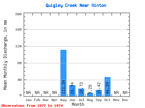
| Statistic | Jan | Feb | Mar | Apr | May | Jun | Jul | Aug | Sep | Oct | Nov | Dec | Annual |
|---|---|---|---|---|---|---|---|---|---|---|---|---|---|
| Mean | 111.23 | 26.94 | 18.67 | 9.34 | 15.42 | 46.38 | |||||||
| Standard Deviation | 3.84 | 16.29 | 7.44 | 1.07 | 16.77 | ||||||||
| Min | 108.52 | 15.42 | 11.38 | 8.40 | 3.56 | 46.38 | |||||||
| Max | 113.95 | 38.46 | 26.25 | 10.50 | 27.27 | 46.38 | |||||||
| Coefficient of Variation | 0.03 | 0.60 | 0.40 | 0.12 | 1.09 |
 Return to R-Arctic Net Home Page