|
|
|||||||||||||||||
| Point ID: 6169 | Downloads | Plots | Site Data | Code: 3095 |
|
|
|||||||||||||||||
| Download | |
|---|---|
| Site Descriptor Information | Site Time Series Data |
| Link to all available data | |
| View: | Time Series | All |
| Units: | m3/s |
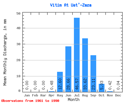
| Statistic | Jan | Feb | Mar | Apr | May | Jun | Jul | Aug | Sep | Oct | Nov | Dec | Annual |
|---|---|---|---|---|---|---|---|---|---|---|---|---|---|
| Mean | 0.00 | 0.00 | 0.00 | 0.48 | 12.60 | 28.66 | 46.56 | 33.62 | 23.11 | 5.02 | 0.42 | 0.04 | 149.54 |
| Standard Deviation | 0.01 | 0.00 | 0.00 | 0.93 | 8.64 | 27.40 | 42.00 | 27.42 | 19.69 | 2.88 | 0.29 | 0.05 | 79.78 |
| Min | 0.00 | 0.00 | 0.00 | 0.00 | 4.13 | 3.29 | 4.54 | 4.34 | 1.90 | 1.12 | 0.07 | 0.00 | 42.24 |
| Max | 0.04 | 0.00 | 0.00 | 4.27 | 45.07 | 141.28 | 166.34 | 98.63 | 91.08 | 12.52 | 1.14 | 0.17 | 352.19 |
| Coefficient of Variation | 4.59 | 1.94 | 0.69 | 0.96 | 0.90 | 0.82 | 0.85 | 0.57 | 0.67 | 1.26 | 0.53 |
 Return to R-Arctic Net Home Page