|
|
|||||||||||||||||
| Point ID: 6158 | Downloads | Plots | Site Data | Code: 3076 |
|
|
|||||||||||||||||
| Download | |
|---|---|
| Site Descriptor Information | Site Time Series Data |
| Link to all available data | |
| View: | Time Series | All |
| Units: | m3/s |
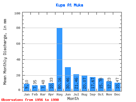
| Statistic | Jan | Feb | Mar | Apr | May | Jun | Jul | Aug | Sep | Oct | Nov | Dec | Annual |
|---|---|---|---|---|---|---|---|---|---|---|---|---|---|
| Mean | 9.10 | 7.41 | 7.48 | 10.33 | 80.15 | 30.46 | 21.46 | 20.07 | 17.67 | 15.78 | 12.23 | 10.46 | 241.26 |
| Standard Deviation | 2.54 | 2.08 | 1.93 | 5.60 | 18.02 | 15.70 | 8.64 | 8.76 | 5.70 | 5.40 | 4.76 | 3.21 | 45.91 |
| Min | 5.42 | 4.00 | 4.33 | 4.04 | 37.03 | 11.91 | 8.15 | 8.49 | 9.73 | 6.29 | 5.83 | 5.69 | 156.76 |
| Max | 18.58 | 15.28 | 14.60 | 27.20 | 108.08 | 86.17 | 49.46 | 53.32 | 34.09 | 36.19 | 28.96 | 18.82 | 405.77 |
| Coefficient of Variation | 0.28 | 0.28 | 0.26 | 0.54 | 0.23 | 0.52 | 0.40 | 0.44 | 0.32 | 0.34 | 0.39 | 0.31 | 0.19 |
 Return to R-Arctic Net Home Page