|
|
|||||||||||||||||
| Point ID: 6150 | Downloads | Plots | Site Data | Code: 3057 |
|
|
|||||||||||||||||
| Download | |
|---|---|
| Site Descriptor Information | Site Time Series Data |
| Link to all available data | |
| View: | Time Series | All |
| Units: | m3/s |
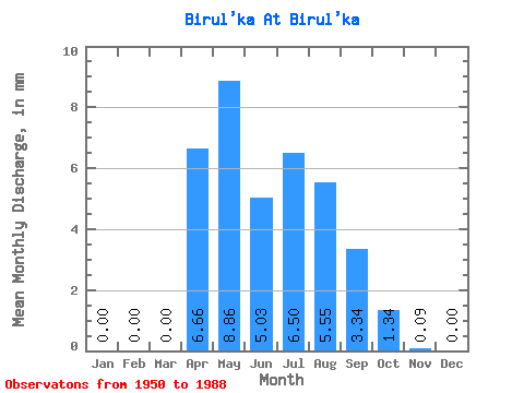
| Statistic | Jan | Feb | Mar | Apr | May | Jun | Jul | Aug | Sep | Oct | Nov | Dec | Annual |
|---|---|---|---|---|---|---|---|---|---|---|---|---|---|
| Mean | 0.00 | 0.00 | 0.00 | 6.66 | 8.85 | 5.02 | 6.49 | 5.55 | 3.34 | 1.34 | 0.10 | 0.00 | 37.17 |
| Standard Deviation | 0.00 | 0.00 | 0.00 | 7.35 | 6.62 | 4.20 | 7.64 | 8.60 | 3.83 | 1.51 | 0.19 | 0.00 | 22.18 |
| Min | 0.00 | 0.00 | 0.00 | 0.18 | 0.17 | 0.41 | 0.04 | 0.13 | 0.16 | 0.08 | 0.00 | 0.00 | 4.80 |
| Max | 0.00 | 0.00 | 0.00 | 37.49 | 24.29 | 19.44 | 35.39 | 46.20 | 15.27 | 7.46 | 1.02 | 0.00 | 105.67 |
| Coefficient of Variation | 1.10 | 0.75 | 0.84 | 1.18 | 1.55 | 1.15 | 1.13 | 1.97 | 0.60 |
 Return to R-Arctic Net Home Page