|
|
|||||||||||||||||
| Point ID: 615 | Downloads | Plots | Site Data | Code: 07AF004 |
|
|
|||||||||||||||||
| Download | |
|---|---|
| Site Descriptor Information | Site Time Series Data |
| Link to all available data | |
| View: | Time Series | All |
| Units: | m3/s |
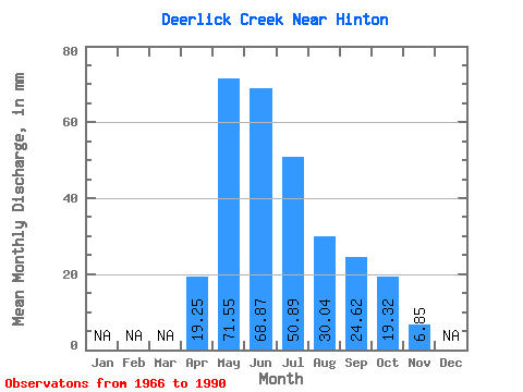
| Statistic | Jan | Feb | Mar | Apr | May | Jun | Jul | Aug | Sep | Oct | Nov | Dec | Annual |
|---|---|---|---|---|---|---|---|---|---|---|---|---|---|
| Mean | 19.20 | 71.49 | 68.86 | 50.80 | 30.05 | 24.55 | 19.28 | 6.85 | |||||
| Standard Deviation | 14.28 | 38.20 | 50.37 | 41.00 | 27.37 | 20.61 | 16.46 | 4.06 | |||||
| Min | 1.48 | 20.47 | 12.03 | 8.80 | 4.78 | 3.89 | 2.29 | 3.89 | |||||
| Max | 53.32 | 185.93 | 253.65 | 154.37 | 105.40 | 76.28 | 73.26 | 11.48 | |||||
| Coefficient of Variation | 0.74 | 0.53 | 0.73 | 0.81 | 0.91 | 0.84 | 0.85 | 0.59 |
 Return to R-Arctic Net Home Page