|
|
|||||||||||||||||
| Point ID: 6148 | Downloads | Plots | Site Data | Code: 3055 |
|
|
|||||||||||||||||
| Download | |
|---|---|
| Site Descriptor Information | Site Time Series Data |
| Link to all available data | |
| View: | Time Series | All |
| Units: | m3/s |
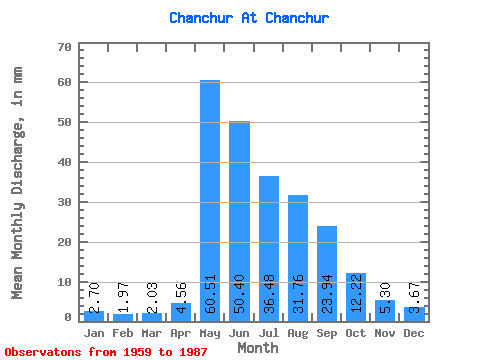
| Statistic | Jan | Feb | Mar | Apr | May | Jun | Jul | Aug | Sep | Oct | Nov | Dec | Annual |
|---|---|---|---|---|---|---|---|---|---|---|---|---|---|
| Mean | 2.70 | 1.98 | 2.03 | 4.56 | 60.50 | 50.40 | 36.47 | 31.76 | 23.95 | 12.22 | 5.30 | 3.67 | 234.78 |
| Standard Deviation | 0.84 | 0.49 | 0.40 | 4.16 | 15.91 | 13.46 | 21.01 | 20.08 | 14.81 | 6.08 | 2.27 | 1.49 | 57.34 |
| Min | 1.58 | 1.10 | 1.30 | 1.71 | 29.29 | 22.33 | 12.86 | 11.00 | 8.89 | 5.06 | 2.02 | 1.53 | 149.64 |
| Max | 5.06 | 3.42 | 2.88 | 19.50 | 91.90 | 72.32 | 84.47 | 83.08 | 66.93 | 35.04 | 11.46 | 8.08 | 380.19 |
| Coefficient of Variation | 0.31 | 0.25 | 0.20 | 0.91 | 0.26 | 0.27 | 0.58 | 0.63 | 0.62 | 0.50 | 0.43 | 0.41 | 0.24 |
 Return to R-Arctic Net Home Page