|
|
|||||||||||||||||
| Point ID: 6147 | Downloads | Plots | Site Data | Code: 3042 |
|
|
|||||||||||||||||
| Download | |
|---|---|
| Site Descriptor Information | Site Time Series Data |
| Link to all available data | |
| View: | Time Series | All |
| Units: | m3/s |
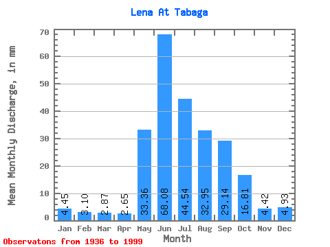
| Statistic | Jan | Feb | Mar | Apr | May | Jun | Jul | Aug | Sep | Oct | Nov | Dec | Annual |
|---|---|---|---|---|---|---|---|---|---|---|---|---|---|
| Mean | 4.45 | 3.12 | 2.87 | 2.65 | 33.35 | 68.08 | 44.53 | 32.95 | 29.14 | 16.81 | 4.42 | 4.92 | 246.55 |
| Standard Deviation | 0.99 | 0.66 | 0.56 | 0.54 | 10.89 | 15.63 | 13.19 | 11.03 | 10.00 | 4.51 | 1.04 | 0.99 | 40.15 |
| Min | 2.44 | 1.81 | 1.81 | 1.87 | 10.12 | 30.34 | 21.55 | 12.99 | 13.55 | 9.02 | 2.60 | 3.02 | 176.86 |
| Max | 7.20 | 4.84 | 4.42 | 4.59 | 62.70 | 103.74 | 76.43 | 68.07 | 59.81 | 28.87 | 6.56 | 7.52 | 369.81 |
| Coefficient of Variation | 0.22 | 0.21 | 0.19 | 0.20 | 0.33 | 0.23 | 0.30 | 0.34 | 0.34 | 0.27 | 0.23 | 0.20 | 0.16 |
 Return to R-Arctic Net Home Page